
Parking — be it on-street or off-street — has become a huge challenge for last-mile and on-demand delivery drivers, especially in urban areas. Cities have limited space. Curb spaces are shrinking. And there’s a spike in traffic density due to the rise of online delivery and shared mobility services.
Tight delivery schedules make it difficult for drivers to find safe/available parking spots close to their drop-off/pick-up points. And then there’s the added burden of parking fees, fines and seized vehicles.
You’d find many posts on discussion forums like Reddit where delivery drivers come seeking solutions for parking problems. “If there’s no free and available parking within a block or so of the restaurant, I unassign and leave and let it be someone else’s problem,” one driver shared.
It’s a lose-lose situation for drivers, businesses and city authorities, as parking challenges lead to traffic congestion, delayed deliveries, declined/unassigned orders and order cancellations.
The solution to this problem is that the driver app should help delivery agents find and navigate to the right parking spots. Businesses can enable this by investing in enterprise-centric mapping solutions that offer support for on-street and off-street parking.
A brief overview of what on-street parking is
On-street parking refers to spaces on a street that are available to drivers to park their vehicles. A great amount of uncertainty is attached to on-street parking because designated areas where people can park — free or paid — are finite. Availability varies depending on a host of different elements, like the time of the day or holiday peak season. In addition, the laws and regulations governing each space also vary from neighborhood to neighborhood.
It is this uncertainty that creates parking challenges for last-mile and on-demand delivery drivers. They have to worry about things like how long it will take to find a parking space, how far it will be from the destination, fuel/time/money wastage and missed delivery windows.
A brief overview of what off-street parking is
Off-street parking refers to indoor or outdoor private parking spaces off the street. It includes garages and private/public lots. There is a set of rules, constraints, fees and/or restrictions that a person has to be mindful of while off-street parking.
Limited availability, proximity to the drop-off point and cost are three factors that help drivers determine which facility they should use. But lack of information orvisibility on limitations such as vehicle size restrictions or time-restricted entry can make it difficult for drivers to rely on off-street parking facilities.
Six reasons why you need mapping solutions to tackle on-street and off-street parking issues
The user experience of a mobility-driven service is deeply tied to maps. Mapping solutions, products and tools developed for business use cases can help combat parking challenges.
We’ve listed not one but six reasons why you should leverage modern mapping solutions if you are looking to solve parking challenges:
1. For accurate and customized parking map data
To build a strong base for any mobility-driven business, you need fresh, accurate and customized map data. A parking data layer in your custom map stack tailored to your business use cases can help drivers/riders find parking spots in relevant locations. You need map data that captures all the local nuances and business-critical location attributes.
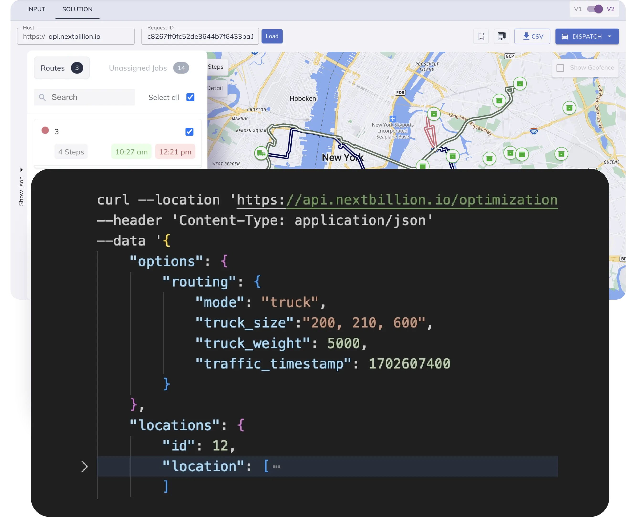
NextBillion.ai offers a map data management service that scans through a range of geospatial data to identify off-street and on-street parking zones (with availability, timings and pricing). This includes public, proprietary, historical and real-time traffic geospatial data, along with aerial and street imagery.
2. To reflect temporary/permanent no-parking zones in your optimized routes
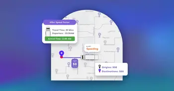
A good mapping solution would allow you to mark on-street and off-street parking spots on your routes based on availability, opening/closing hours and fees. You can also reflect parking regulations set by each city’s traffic authorities on your map. For example, in Seattle, commercial vehicles are allowed to park and load/unload for up to 30 minutes in alleys.
NextBillion.ai enables companies, like this e-scooter micromobility company, to insert custom routing attributes and restrictions via its Route Optimization API that comes with the built-in flagship Road Restriction Tool.
3. To seamlessly navigate drivers to parking spots
Your app for delivery drivers should not only offer turn-by-turn guidance but also reflect other useful information required for a smooth navigation experience. For instance, drivers would benefit from knowing real-time traffic situations, available off-street and on-street parking options, parking insights for a specific location and driving/walking time to the drop-off point.
NextBillion.ai’s Navigation SDK comes with a curbside feature that allows users to set a parking location for each waypoint from the origin to the destination, whether it’s in the direction of the vehicle going down the road, or across the road. You can also insert custom POIs, routing preferences and data insights.
Our Directions API can calculate routes for different vehicles (like cars, bikes, EVs and trucks), profiles (like driving and walking), waypoints and travel times. And our Route Optimization API with a built-in traveling salesman problem solver, vehicle routing problem solver and custom map stack can help identify the best parking options available around a destination.
4. To improve parking availability prediction
Gain insights into parking availability through location intelligence and map data solutions to plan your routes better.
These solutions analyze historical parking trends, traffic patterns, temporary restrictions and road congestion to predict off-street and on-street parking options for each street/location. Information about parking availability is updated at regular intervals.
5. To compute accurate ETAs for different parking spots
Speaking of improving parking predictions, accurate ETAs for multiple off-street and on-street parking locations also immensely contribute to achieving that goal.
Last-mile delivery drivers have to complete their tasks within very tight delivery windows. Our Distance Matrix API enables businesses to calculate accurate ETAs for parking spots nearest to each driver/rider, pick-up point(s), and drop-off point(s). It can efficiently handle a 5000*5000 matrix size and generate precise ETAs within a few seconds.
6. For plug-and-play off-street and on-street parking APIs
Leverage off-the-shelf parking APIs if location data isn’t a core component of your operations or you just need some basic functionality. This can help reduce the required investment if you are in the early stages of product development or have a low scale of operations.
Off-street and on-street parking APIs allow users to find available parking options, sort the options based on fees and restrictions, and enable navigation to the selected parking spot.
Who can utilize the parking insights gained from smart map solutions?
The data generated by mapping solutions offer critical insights that can help businesses (not just delivery-centric businesses) solve a wide range of problems. Here are a few examples of who can benefit from it and where it can be applied:
- As parking is the first touchpoint in the customer journey, businesses can assess the proximity of their stores to off-street and on-street parking options and implement a remedial action plan to boost the customer experience
- It can help businesses increase/decrease the capacity of their private parking lots, decide opening/closing hours, decide fees and adjust limitations
- Information about the parking situation can also help companies to choose the right location for their business
- Parking companies can use these insights to identify areas with low off-street parking options and benefit from opening new parking facilities
- It can assist mobility-driven businesses and drivers in evaluating parking options in advance and planning their routes accordingly
- It will allow companies to make information about on-street parking options easily accessible to drivers in the absence of feasible off-street options, and vice versa
- These insights can effectively solve heavy traffic congestion problems by helping cities and road authorities identify locations with chronically low parking availability and slow-moving traffic
- With this insight, businesses can provide valuable information to drivers about areas with the highest and off-street/on-street parking success rates for effective route planning
Modern mapping solutions are helping businesses to figure out how they can effectively solve parking problems and make smart business decisions. They’re also helping city administrators reduce traffic congestion, free up city space and keep regulatory compliance work on track.
We have helped many companies to plan routes from the last mile to the last yard and consistently hit their on-time delivery KPIs.
If you are looking for custom map data, route optimization and navigation solutions that can reflect parking attributes and restrictions, get in touch with NextBillion.ai.
Ready to get started?
Talk to SalesGet routes that need no editing or on-road improvisations
Ready to up your game in scheduling, dispatch, and routing?
Request a Demo